Development Version 2.00 (December 2007)
Changes
There have been numerous changes, below is a list of just some of the major ones.
- Multi page support with screens that can be designed by the user using a program which runs on a PC.
- More than 50 new parameters have been added.
- Profiles for altitude and speed.
- If the Communication Port is set to "Auto" it will search all serial ports at all baud rates for a GPS which is outputting NMEA.
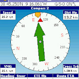
- Compass for navigation to next waypoint.
- 3 Odometers are available for measuring distance.
 |
| OziCe2_0 |
Development Version 2.01 (December 2007)
Changes
- For Pocket PC's, full screen mode now works on all pages which have a map on the page.
- Screen Control now works on all pages except the options and satellite view pages.
- If a page file is loaded which is meant for a PDA with a smaller screen, any map windows on the page are expanded until the parameters fill the available area. If there is no map window on the page the parameters are centered on the screen. While this does help the best option still is to design a set of pages to suit the screen size of your PDA using the Settings Manager. This only works with page files created with Version 2.01 of the Settings Manager, if you load them into the Settings Manager and resave they will be ok.
- When put into full screen mode (Pocket PC's only) or the Main Toolbar is turned off the pages are also resized if there is a map window on the page.
- The OziExplorer.key1 file has been fixed and now contains button defaults for the screen control.
- This was in the previous version and wasn't mentioned - the number of loaded waypoints has been increased to 2000 and you can keep loading waypoint files until the limit is reached. <------
- Changes have also been made to the Settings Manager and a new version is available for download.
- Many other smaller issues have been fixed.
UPDATE again
Development Version 2.02 (January 2008)
Changes
- New version of Settings Manager is available.
- All the issues of buttons not working / being drawn at the wrong locations should now be fixed.
- Fixed bug where transparent parameters were not drawn at the correct location.
- Added sound when waypoint created - "wp_create.wav" in the Sound Files folder. The sound can be changed by using a different wav file renamed. The sound can be removed by deleting the sound file.
- Added additional buttons to the Settings Manager to reset Odometers without a confirmation dialog - sound is played when reset - "odometer_reset.wav" in the Sound Files folder. The page files we provide use the buttons which require a confirmation, you will need to copy and modify the supplied page files to change the buttons to have no confirmation.
- The "Satellite" page can now be turned off on the "Page Selection" dialog - however it will always show until the GPS has a valid fix.
- Management of waypoints has been significantly changed, see the help section below for details.
- Management of the track displayed on the map (now called "Track Tail") has changed, see help section below for details.
- MGRS position display format has been added.
- Display of the current Position in various ways has been added to the Settings Manager.
- The ability to "project" a waypoint from current position or another waypoint has been added. "File / Waypoints / Project New Wp" menu option.
- New options have been added to the "Map / Screen / Screen Control" menu as follows:
- Hide Toolbars - If ticked when the Screen Control is activated the Toolbars will hide, when unticked any toolbars which are visible will stay visible.
- Has Priority - If ticked the Screen Control buttons will have priority over any option buttons under it, when unticked the option buttons will have priority.
- Added the ability to move to specific page numbers as commands for the settings manager.
- Added a "Nearest Waypoint List" as a parameter to the Settings Manager. This can be placed on any page and shows the waypoints in a scrollable list in order of distance from current position. Buttons are provided to show a selected waypoint on the map and to "Go to" the waypoint. The Nearest Waypoint List has been added to our standard page files.
- Many other minor issues have been fixed.
Sem comentários:
Enviar um comentário