Dear Friends, Wow - on Saturday, in desperate last-minute negotiations, the world faced down an effort by the US, Canada and Japan to wreck the crucial Bali Climate Change Summit. Over 600,000 Avaaz members mobilized to save the Bali talks, including 320,000 in the final 72 hours! Click below to read the whole story with photos and videos: http://www.avaaz.org/en/bali_report_back/6.php Arriving in Bali, most countries wanted to work towards a new global treaty on climate change as well as new targets for carbon emissions by rich countries. But late last week, the US and Canada teamed up to undermine the talks -- the US blocked the whole Bali summit consensus, and when a smaller group of Kyoto treaty countries tried to move ahead without the US, they were blocked by Canada. The summit was in danger of deadlock. The Avaaz community flew into action, signing and spreading petitions to each of the governments, supporting ad campaigns in Bali and Canada, marches around the world, and phoning and lobbying elected officials. At the summit, Avaaz members brought the storm of public criticism inside the conference walls with the only march allowed inside the venue, the largest climate petition delivery in history, daily press conferences and "fossil awards" for the worst countries in the negotiations, and constant lobbying of officials. In the final hours of the summit, Canada backed down completely and allowed Kyoto countries to agree to strong 2020 targets on carbon emissions, and the US team, now entirely isolated and actually booed by the world's diplomats, compromised and agreed to call for "deep cuts" and "reference" the 2020 targets. This paved the way for the summit to agree to sign a new global climate change treaty by 2009. Usually these conferences are stuffy diplomatic affairs - but this time the world was watching, and speaking, each day. Together, we brought people-powered politics to the halls of power, and put our governments on notice: in the fight to save our environment, we will not be spectators. Click below to see a report on this campaign with videos and pictures: http://www.avaaz.org/en/bali_report_back/6.php This is just the beginning. Every nation of the world has now agreed that they will enter into accelerated negotiations and, by 2009, sign a new treaty to confront global warming. We need this treaty to set binding global targets for carbon emissions, and a mechanism for meeting them, that keep the earth's temperature from rising more than 2 degrees celsius - the amount that scientists say would be 'catastrophic'. Such a treaty will change the world's economy forever, weaning us off oil and fossil fuels to cleaner sources of energy. Some leaders, in the pocket of the oil industry, will fight it tooth and nail all the way. And we will too. A great struggle to save our environment has begun, and this weekend, we showed together that the people of the world aren't intending to sit this one out. With much respect and appreciation for this amazing community of people, Ricken, Ben, Milena, Paul, Iain, Sarah, Galit, Pascal and the whole Avaaz Team.
quarta-feira, dezembro 19, 2007
Também ajudei a derrotar os americanos. :-)
Nos últimos tempos tem sido evidente o isolamento dos Americanos no que concerne às medidas que conduzam a começarmos todos a preocupar-nos a sério com as questões ambientais. Vidé caso do protocolo de Quioto que os Americanos se recusam teimosamente a assinar, mesmo depois da Australia, após uma mudança de governo, ter finalmente aderido e assinado o documento que leva à redução da emissãos de gases poluentes para a atmosfera.
Nas últimas duas semanas ocorreu a Cimeira de Bali dedicada às alterações climáticas, que teve uns últimos dias dramáticos devido à teimosia de três países (depois dois e finalmente apenas um teimoso; os USA) em assinar as conclusões de um painel alargadíssimo de países e entidades que se preocupam com a questão do ambiente.
Eu tenho a satisfação de também ter dado uma pequena contribuição e por isso recebi agora o seguinte mail;
segunda-feira, dezembro 17, 2007
O novo OziCE
Saiu hà dias a nova versão do OziCE.
Chegou-me a novidade através do Yahoo Ozi_Users_CE group e nestes últimos dias tenho acompanhado as cabeçadas dos que foram a correr experimentar a nova versão. ;-)
Hoje, quando comecei a ver mensagens já animadoras instalei-o e comecei a experimentar.
As novidades são muitas e algumas delas bem interessantes.
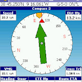
Para mim, o que mais 'me fazia falta' era a setinha integrada na bussola para indicar a direcção e distância ao waypoint.
Encontrei apenas dois pequenos pormenores;
- na projecção de um novo ponto não o faz a partir da localização actual mas sim de um waypoint. Então, tem que se criar um waypoint na localização actual e depois fazer a projecção a partir dele.
- nos écrans da bússola não indica o nome do waypoint seleccionado.
São estas melhorias mais destacadas pelo próprio site;
Experimentei-o no caminho entre o trabalho e minha casa (fui tirando 'fotos' ao écran usando o PocketPC screen capture) e fui navegando para uma cache para ver se funcionava bem a bussola integrada com mapas topográficos detalhados.
Só uma palavra; Maravilha! :-))
UPDATE:
E, claro, as cabeçadas (incluindo agora as minhas ;-)) já deram resultado:
Development Version 2.00 (December 2007)
Changes
There have been numerous changes, below is a list of just some of the major ones.
- Multi page support with screens that can be designed by the user using a program which runs on a PC.
- More than 50 new parameters have been added.
- Profiles for altitude and speed.
- If the Communication Port is set to "Auto" it will search all serial ports at all baud rates for a GPS which is outputting NMEA.
- Compass for navigation to next waypoint.
- 3 Odometers are available for measuring distance.
 |
| OziCe2_0 |
Development Version 2.01 (December 2007)
Changes
- For Pocket PC's, full screen mode now works on all pages which have a map on the page.
- Screen Control now works on all pages except the options and satellite view pages.
- If a page file is loaded which is meant for a PDA with a smaller screen, any map windows on the page are expanded until the parameters fill the available area. If there is no map window on the page the parameters are centered on the screen. While this does help the best option still is to design a set of pages to suit the screen size of your PDA using the Settings Manager. This only works with page files created with Version 2.01 of the Settings Manager, if you load them into the Settings Manager and resave they will be ok.
- When put into full screen mode (Pocket PC's only) or the Main Toolbar is turned off the pages are also resized if there is a map window on the page.
- The OziExplorer.key1 file has been fixed and now contains button defaults for the screen control.
- This was in the previous version and wasn't mentioned - the number of loaded waypoints has been increased to 2000 and you can keep loading waypoint files until the limit is reached. <------
- Changes have also been made to the Settings Manager and a new version is available for download.
- Many other smaller issues have been fixed.
UPDATE again
Development Version 2.02 (January 2008)
Changes
- New version of Settings Manager is available.
- All the issues of buttons not working / being drawn at the wrong locations should now be fixed.
- Fixed bug where transparent parameters were not drawn at the correct location.
- Added sound when waypoint created - "wp_create.wav" in the Sound Files folder. The sound can be changed by using a different wav file renamed. The sound can be removed by deleting the sound file.
- Added additional buttons to the Settings Manager to reset Odometers without a confirmation dialog - sound is played when reset - "odometer_reset.wav" in the Sound Files folder. The page files we provide use the buttons which require a confirmation, you will need to copy and modify the supplied page files to change the buttons to have no confirmation.
- The "Satellite" page can now be turned off on the "Page Selection" dialog - however it will always show until the GPS has a valid fix.
- Management of waypoints has been significantly changed, see the help section below for details.
- Management of the track displayed on the map (now called "Track Tail") has changed, see help section below for details.
- MGRS position display format has been added.
- Display of the current Position in various ways has been added to the Settings Manager.
- The ability to "project" a waypoint from current position or another waypoint has been added. "File / Waypoints / Project New Wp" menu option.
- New options have been added to the "Map / Screen / Screen Control" menu as follows:
- Hide Toolbars - If ticked when the Screen Control is activated the Toolbars will hide, when unticked any toolbars which are visible will stay visible.
- Has Priority - If ticked the Screen Control buttons will have priority over any option buttons under it, when unticked the option buttons will have priority.
- Added the ability to move to specific page numbers as commands for the settings manager.
- Added a "Nearest Waypoint List" as a parameter to the Settings Manager. This can be placed on any page and shows the waypoints in a scrollable list in order of distance from current position. Buttons are provided to show a selected waypoint on the map and to "Go to" the waypoint. The Nearest Waypoint List has been added to our standard page files.
- Many other minor issues have been fixed.
Subscrever:
Comentários (Atom)